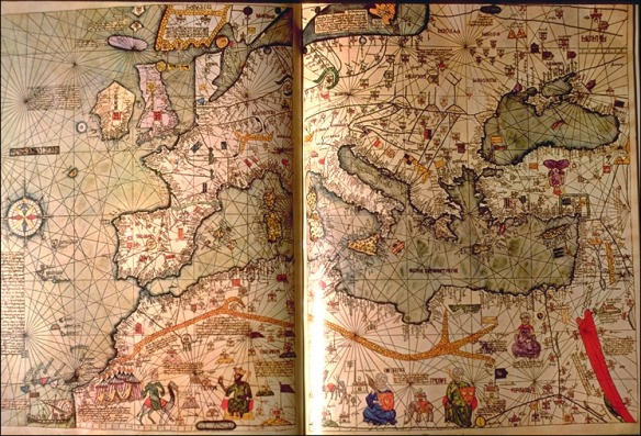
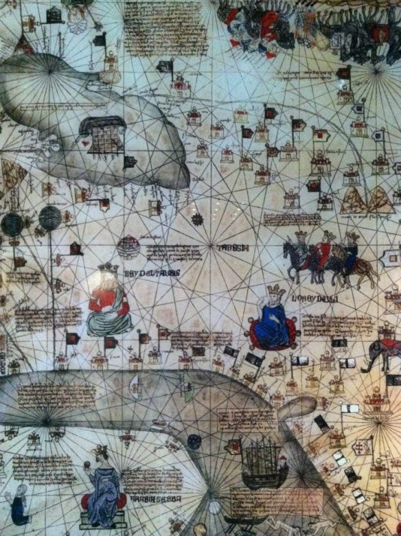
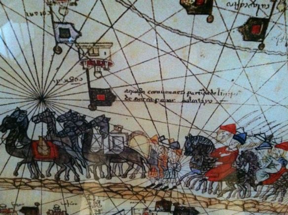
In the year 1380, while Charles V, the king of France was embroiled in the “Hundred Years’ War” with the English, he was presented with a unique item by his cousin, Pedro IV, the ruler of Aragon. The Catalan Atlas of 1375 (see below), drawn with a stunning variety of colors, despite being a portolan chart, depicts most of the known world. Although it contains multiple elements and represents numerous regions, this piece will focus in particular on its depiction of the Mediterranean. The lack of any detailed scholarship pertaining to the Catalan Atlas is particularly striking, especially in light of the fact that it was drawn during the height of Aragonese rule in the Mediterranean.
Since their rise to power in the mid-thirteenth century, the Aragonese had pursued a policy of imperial maritime expansion, driven by religious fervor, strategic considerations, and, naturally, by economic interests. In 1229, the island of Majorca, which had been in Muslim hands since 902, fell to the Aragonese, who then proceeded to conquer Sicily, Minorca, Ibiza, Sardinia, southern Italy up to Naples, and even parts of Greece and Asia Minor. Therefore, by the time that Abraham Cresques, an Iberian Jewish cartographer, had completed the Catalan Atlas in 1375, the Crown of Aragon possessed a sea-borne empire, or thalassocracy, that extended from the shores of eastern Iberia to the Peloponnesian peninsula in the eastern Mediterranean. The Aragonese “empire” was never really a unified entity, but rather a loose confederation of small principalities. Regional Catalan lords in Sicily, Majorca and Greece ruled and administrated their territories semi-independently of royal authority, although there was a strong sense of loyalty to the Crown of Aragon.
Even though it takes the form of a portolan chart, the Catalan Atlas incorporates various elements, such as iconography, imagery, and the symbolic use of color. It places emphasis on the economic and strategic routes of the Mediterranean, which would have had a practical purpose for the Aragonese, and also the representation of the Catalan-ruled entities across the Mediterranean as somehow unified, despite the fact that the Aragonese “empire” was, in reality, nothing more than a loose confederacy of territories. In order to better understand the Catalan Atlas and appreciate its significance, it needs to be contextualized within this “imperial reality” of the Crown of Aragon in the fourteenth-century Mediterranean. In this regard, the point of departure for the discussion of the Catalan Atlas should be the thematic question: to what extent does the Catalan Atlas of 1375 reflect the imperial reality of the Aragonese thalassocracy? In order to answer this question, it is necessary to first delineate the politico-historical facts about the Catalans in the Mediterranean in the Late Middle Ages in order to define the precise nature of this “imperial reality.”
Historical Background
The era of European maritime exploration and colonization is generally purported to have begun in 1492, when Christopher Columbus set foot in the New World and claimed it in the name of Castile. Almost a century before Columbus, however, there existed in the Mediterranean (and, to a lesser degree, parts of the eastern Atlantic) a vast dominion, more of a confederacy than an empire, of Catalan principalities under the nominal rule of the Crown of Aragon. The chain of islands in the Mediterranean (and the Atlantic) dually constituted a collection of stepping stones towards the religiously significant Levant, and lucrative spice trade in the East, and simultaneously a naval route to the Atlantic and West African gold.[1]
The rise of the Catalans as an advanced sea-faring nation in the 13th and 14th centuries has its roots in the early 13th century Iberian peninsula, where the Christian reconquista against the Andalusi Muslims was progressing with astonishing success and rapidity. The Battle of Las Navas de Tolosa in 1212 between an Iberian Christian coalition and the Almohads ended in an overwhelming victory for the Spanish Christians, essentially ending Muslim domination over most of central Iberia for the first time in 500 years.
Taking advantage of the weakened Hispano-Muslims, Jaime I of Aragon managed to conquer Valencia and the strategically-important island of Majorca by 1238.[1] The occupation of the Balearics, and especially Majorca, was one of the major factors in influencing the orientation of the Aragonese towards maritime, rather than land-based, expansion.[2] Despite the intensive religious rhetoric employed by Jaime I, known as El Conqueridor in Catalan, the foreign policy of the Crown of Aragon was governed largely by strategic and economic considerations. In other words, despite the religious fervor and ideology of “reconquest,” which no doubt must have informed the semi-imperial outlook of the Catalans, the primary concern that arose after the conquest of Majorca in 1229 was the formation of a strategically and economically viable dominion in the Mediterranean which would allow them to maintain their position as a dominant power in the western Mediterranean. This perception of the world, and their role in it, is particularly relevant to understanding how and why the Catalan Atlas of 1375 is an important representation, on differing levels, of the Aragonese thalassocracy.
Following the conquest of Majorca in 1229, the Catalans embarked on a remarkable venture of island conquests that did not subside until the early fourteenth century. Using crusading ideology as a legitimating tool, the Crown of Aragon effectively controlled the Balearic Islands, Sicily, Sardinia, and parts of Greece and Asia Minor by 1330.[3] They even managed to secure exclusive rights and privileges for Catalan merchants in some North African cities. Although the governors of the Aragonese territories in the Mediterranean were, in theory, subordinate to the king in Barcelona, in reality they ruled their islands as independent principalities. Moreover, despite the coherence in economic and strategic policy, each of the Catalan dominions, with the possible exception of Majorca, behaved as virtually independent kingdoms. Religion was used as a tool of legitimization for empire; Jaime II, writing to the Pope in 1311 claimed that Aragonese conquests were made so that
“the Christian army, in proceeding towards the East by way of the sea, might always have islands of Christians to cling to: that is, Majorca, Sardinia, and Sicily, from where they might always be able to draw victuals and refreshments and men to reinforce the said army and settle new homelands and by acquiring a base might be able, with God’s help, to reach the Holy Land.”[4]
Although religious ideology played an important role in the legitimization and consolidation of their conquests, the Aragonese were largely driven by strategic and commercial considerations. The conquest of Majorca marked the beginning of the rise of the Catalans as a dominant political, military, and economic force in the western Mediterranean. Following the completion of the conquest of Majorca in 1229 and Valencia in 1238, the Catalans shifted their attention towards the central Mediterranean and Sicily, where they became involved in the War of the Sicilian Vespers (1282-1302).[5] Their intervention in Sicily eventually led to the establishment of Aragonese authority on the island, a victory which gave the Catalans control of major trade routes and strategic outposts in the Mediterranean. Sicily, like Majorca, became one of the most important Aragonese domains in the Mediterranean, but, unlike Majorca, Sicily was ruled far more independently of the Crown of Aragon. Soon after the conquest of Aragonese conquest of Sicily, a significant event occurred in the East which shook Christendom to its core: the Kingdom of Acre, the last Crusader State in the Levant, fell to the Muslim Mamluks in 1291. Partially in response to this event, a semi-piratical crusading organization, known as the Catalan Company or Almogavares, journeyed to the eastern Mediterranean.[6]
They derived their strength largely from hired mercenaries, including many Muslims and Jews, and their mobile form of warfare. Following their defeat of the Turks in Asia Minor during the early 14th century, they ventured into the Byzantine Empire, which attempted (but failed) to expel the Almogavares and, consequently, they managed to establish themselves in the Peloponnesian peninsula and form the Duchy of Athens in 1311.[7] The Catalan state in the East was largely independent but relied on the Crown of Aragon for supplies and reinforcements, especially as Turkish strength in the Aegean and the eastern Mediterranean grew. The Duchy of Athens remained an important commercial and strategic outpost for the Crown of Aragon until its fall in 1388. Although the Duchy was virtually autonomous, it was considered by the Aragonese to be a part of their imperium in the Mediterranean.
Probably the most brutal and costly conquest of the Aragonese was in their campaign against Sardinia, which they did not subjugate until the 1320s, and even then only partially.[8] The constant rebellions of the Sardinians and the general failure of the Aragonese to maintain full control over the island meant that the Crown of Aragon entered a general state of decline and political decadence between 1327 and 1387, although it was also the period in which Aragonese expansionist policies were pursued most vigorously.[9] Therefore, it is apparent that the Catalans controlled a largely fragmented Mediterranean domain which was only nominally subject to the Crown of Aragon. Most of the primary sources also give a clear indication that the so-called “Aragonese Empire” was faced with constant problems, complex political circumstances and was, in essence, a decentralized confederacy held together only by commercial, strategic, and a common religious identity.[10] It is essential to understand this basic background of the imperial situation of the Aragonese in the late-14th century because it provides the basic context and frame of reference within which the Catalan Atlas of 1375 needs to be understood.
The Catalan Atlas of 1375
Most European world maps of the Middle Ages, known as mappamundi, conform to a certain set of principles. Foremost among them is the depiction of Jerusalem—the city of the Crucifixion and the Resurrection—as the center of the world. Although this should not be taken to mean that all cartographers of medieval Europe believed that Jerusalem was the literal geographic center of the earth (which was understood to be spherical), it reflects a certain tendency among European Christians to represent the world in religious and metaphysical terms. There was also the practicality of depicting Jerusalem at the world’s center in order to provide an understanding of the city’s position (both geographically and spiritually) in relation with the rest of Christendom.
Another element shared by many European maps of the Middle Ages was the almost total lack of description of the political, economic, and strategic aspects of the non-Christian world. In general, many medieval maps were drawn with a limited purpose in mind, and were usually only meant to be utilized by a clearly defined group.[1] For example, a monk would perhaps draw a map showing the pilgrim road to Jerusalem, with indications of such elements as key Christian shrines on the road, hostels, and hostile territory through which pilgrims would have had to travel (especially after the 11th century). On the other hand, a map intended for military use would focus almost exclusively on topographical features relevant to military campaigns. Therefore, there was generally only one layer of information in medieval maps, which were not overly concerned with the representation of geographical reality. As a result of the nature of medieval maps, some scholars have opted for the terminology “diagram” when discussing medieval cartography, and have made the argument that it is more representative of what medieval maps really were: transmission of basic information within the framework of a spatial representation.[2]
The conception of the world and its cartographic representation greatly changed in Europe during the High Middle Ages. The failure of the Crusades, the heightened interest in science and technology, and the rise in the military and economic strength of European powers helped generate this shift. The travels of Marco Polo (d. 1324) created an intensive interest in the wealth and power of the non-Christian world. The Church viewed the vast world to the Far East as a potential missionary arena from which to expand Christendom, while the more worldly-minded expressed excitement about the riches and trade of the Orient. These preoccupations were reflected in cartography as well, and signaled a shift in the European view of the world. It is within this changing perception of Europe vis-a-vis the non-Christian/non-European world that that Catalan Atlas of 1375 needs to be contextualized.
Unlike many European maps of the Middle Ages, the Catalan Atlas does not depict Jerusalem as the world’s center with the rest of humanity gravitating towards it (although, it cleverly uses orientation to ensure that Jerusalem is in the central region of the map). Nor does it represent the non-European world as some sort of monolithic, barbaric entity. In fact, the map demonstrates a great deal of knowledge about the economic, political, and religious situation in the Near East and North Africa by showing trade routes, sites of raw materials and resources, and the numerous dynasties around the Mediterranean. It has been noted that the Catalan Atlas behaves as a sort of encyclopaedic compilation of European knowledge of the world in the late-14th century derived from the travel writings of sailors and explorers such as Marco Polo.[3] The difference in the approach between “traditional” medieval maps and the Catalan Atlas can be explained by the fact that it takes the form of a portolan chart, albeit a unique one. The origin of the portolan chart remains a mystery, but it most likely originates from Arabic nautical charts and southern European coastal maps. The first known portolan appeared in Europe near the end of the 13th century, and was developed by the Catalans, especially those in Majorca, and the Italians.[4] Portolan charts have three main elements that distinguish them from other medieval European maps: orientation, geometry, and accuracy. Portolans are unconcerned with depicting Jerusalem at the world’s center and instead attempt to map geographical landscape, especially coastlines, as accurately as possible. Since they are primarily used for coastal navigation and maritime exploration in the Mediterranean, portolan charts place all the major cities in a particular region on the coastline, to such a degree that it appears that there is no inland settlement, although Catalan portolans are unique in this regard since they also emphasize inland features.[5] Furthermore, straight geometric lines, known as rhumb/nodal lines, are displayed very prominently on the charts in order to aid sailors in navigating the Mediterranean coast. Most of the information in portolans is derived partially from travel writings or astronomical information, and mainly from vast collections of data pertaining to voyages across the Mediterranean and, in this way, emphasize accuracy.[6]
Although the Catalan Atlas possesses all of these characteristics, it also possesses many features that are atypical of portolans. The use of extravagant color to depict navigational routes, trade routes, sources of wealth, various kingdoms, and the incorporation of mythical elements (such as Prester John) reflects earlier portolan charts drawn by Angelino Ducert, also a Majorcan, in 1339.[7] The Catalan Atlas contains multiple layers of information that it attempts to present as a unified, coherent cartographic body of knowledge. While working within the flexible framework of the portolan chart, Abraham Cresques represents the Mediterranean world, in all its complexity, in relation with the Aragonese domain, by using color and iconography. In this way, he provides an overlapping set of information that attempts to convey a broader meaning. It should not be understood that the Catalan Atlas is an absolutely accurate and total representation of spatial information, but rather, that it provides an insight into the mind of the mapmaker—Abraham Cresques—and an understanding of how he attempted to contextualize the so-called “Aragonese empire” within the wider Mediterranean. In this sense, the Catalan Atlas, although not primarily concerned with the Crown of Aragon per se, can be interpreted as an attempt to reflect the “imperial reality” and the imperial preoccupations of the Aragonese in the Mediterranean. Felipe Fernandez-Armesto provides an excellent summary of the Catalan Atlas:
“[The Atlas] is as rich and intricate as a spilled jewel casket, resplendent with images of exotic beings and untold wealth. [Maps] were royal gifts intended for ostentation as well as use, but the modest and practical portolan chart could be drawn with grace and adorned with illustrations or, at least, with fine calligraphy and a delicate set of rhumb lines. It was a period in which maps could inspire more than music.”[8]
Maps and “Imperial Reality”
What is “imperial reality”? To what degree was the Catalan Atlas a “tool of imperialism” used to reify the existence of an Aragonese imperium in the Mediterranean? How does the Atlas reflect the geo-political considerations of the Aragonese in the late 14th century? These are only a few of the questions that are raised by attempting to interpret the Catalan Atlas of 1375 as representative or reflective of an existing status quo in the Mediterranean. Although it would be ideal to provide definitive answers to these questions, I cannot do so in this small piece. Nevertheless, these questions will be used as guidelines for the analysis that follows.
What constitutes a map? This has been a very contentious question in the discourse of the history of cartography. Is a map simply an objective graphic representation of territory or does it reflect a complex collection of spatial knowledge constructed in such a way that is indicative of a larger set of social relations? Brian Harley, perhaps the most influential theorist in the field of the history of cartography, argues in favor of the latter. According to Harley, maps and mapmaking are manifestations of a complex knowledge and power relationship. He defines this relationship as “knowledge as power,” or the association of power with knowledge.[9] In this sense, maps are direct representations of imperial preoccupations since they represent knowledge, through the medium of the map, in ways that emphasize and omit different elements. Maps, in the Harlian conception, are therefore more than simply objective, scientific graphical representations of space. They are manifestations of a complex knowledge-power relationship that posses a specific esoteric meaning. In this sense, it can be said that maps, especially those from early modern Europe, reflect imperial preoccupations but not always clearly. Perhaps the most evident indication that maps are useful in understanding the construction of imperial space is the way in which they are used to legitimize the reality of conquest and empire. True as this may be, there is also another, simpler purpose of maps: utility. Some maps, such as the Catalan Atlas, while presenting the Aragonese domain as a somewhat unified entity, also contains more practical aspects which were of concern to the Catalans in the late medieval period. Such elements as trade routes, strategic harbors, and political divisions, which are all depicted on the Atlas, were all primary considerations of the Catalans in the late fourteenth century. Therefore, while possessing a deeper, albeit unclear, meaning the Catalan Atlas was also an important tool that would have been utilized by the Aragonese in the Mediterranean for practical purposes.[10] In this way, it can be said that the Catalan Atlas is representative, to a certain extent, of the “imperial reality” of the Aragonese-Catalan “empire.”
In the context of the Aragonese imperium, the phrase “imperial reality” is particularly problematic. It falsely assumes that the Crown of Aragon and its Mediterranean possessions were unified under the king in Barcelona. As outlined earlier, this was definitely not the situation in the late-14th century Mediterranean, and the idea of an “Aragonese Empire” has been extensively critiqued by historians.[11] Thus, any discussion of this “imperial reality” does not imply the existence of an Aragonese “empire,” but recognizes that there was a loose confederation of Aragonese polities across the Mediterranean that owed allegiance, at least in theory, to the king in Barcelona. It is this geo-political reality which the Catalan Atlas purports to represent. It is worth recognizing that the period which is being discussed immediately precedes the so-called “Age of Empire” which began around 1492. However, this does not mean that the idea of maps or cartographic expression was any less significant during the late fourteenth century. The focus by such scholars as Harley on of the knowledge-power relationship within cartography in the post-1492 era implies that maps had less significance in the High Middle ages, which is definitely not the case. The Catalan Atlas demonstrates that, despite its production during the medieval period, it can convey an overlapping collection of information in a coherent and advanced way. Although there are numerous contemporary chronicles regarding the events in the Catalan domain throughout the fourteenth century, which provide detailed textual evidence about the “imperial reality” of the Crown of Aragon, the Catalan Atlas is one of the sole surviving cartographic representations of the Aragonese imperium in the western Mediterranean. It is worth posing the following question at this point: why should the Atlas even be consulted if a multitude of more “historical,” textual sources already exist? The answer is not a simple one.
While maps usually do not provide as much detail as textual evidence or discuss the origins of a certain phenomenon, they manage to present a clearer picture of “reality” than most textual sources. Their simplicity, appeal, and utility all provide an intriguing representation of the “wider picture” that exists of a certain phenomenon or at a certain time period. Whether or not maps represent “reality” accurately is a matter of debate and depends, for the most part, on the individual map in question, its context, and its contents. The extent to which maps accurately represent reality is also a far less interesting question than the actual perspective that a particular map is seeking to convey. Their appeal and form make maps ideal political tools of legitimization and domination. However, it is particularly because of its allure and simplicity that cartographic evidence must be used with caution.[12] A coherent attempt to discuss the theoretical complexities of such questions as the nature of maps and why they tend to impose order on spatial representations is not the purpose of this post, but it is essential to keep in mind this idea about maps when discussing the Catalan Atlas of 1375 and the extent to which it reflected Aragonese “imperial reality.”
The Catalan Atlas and Imperial Preoccupations
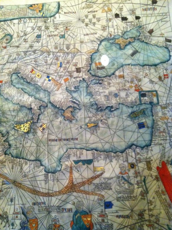
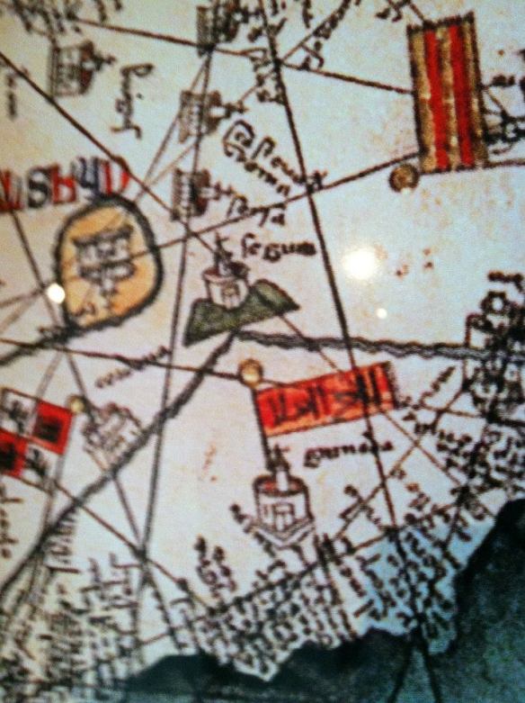
The Catalan Atlas of 1375 contains a multitude of detail that can help scholars understand the imperial preoccupations of the Crown of Aragon in the late fourteenth century. One of the most striking features of the Atlas, in contrast with later maps, is the almost total lack of borders and boundaries. However, due to the inevitable need to differentiate between territories, iconography is employed to delineate between various political domains. This iconography largely takes the form of miniature banners and coats of arms. The Catalan Atlas indicates Aragonese-ruled territory using the gold- and ruby-colored senyera (Catalan flag). It is visibly present on the islands of Sicily and Majorca, but is also used to designate the lands of the Crown of Aragon around Valencia, Barcelona, and Zaragoza on the Iberian peninsula. Oddly, the senyera is noticeably absent from the Catalan-dominated island of Sardinia, and from the Catalan Duchy of Athens which was, as discussed above, founded by the semi-piratical Catalan Company.[13] There can be two major reasons why Abraham Cresques opted to ignore the fact that these territories were Catalan-ruled. During the late-14th century, the Aragonese was in a temporary state of decline, and was ill-equipped to aid their Catalan brethren in the East who were facing the growing power of the Ottoman Empire. Similarly, Sardinia was in constant rebellion against the Aragonese and was seeking Genoese aid, and thus was not under the complete authority of the Crown of Aragon. Therefore, the depiction of these territories as somewhat unimportant and “peripheral” in relation with the Crown of Aragon may have aimed to divert attention from the failure of the weakening strength of the Catalans in both the Peloponnesian peninsula and Sardinia. In this regard, it should be remembered that this map was being presented to the king of France, a potential rival to the Crown of Aragon, and therefore the king of Aragon would have wanted to demonstrate that he had full authority over his territory.
In other words, by depicting only the stable and successful territories of the Crown of Aragon, while ignoring the less-powerful and “peripheral” lands, the Catalan Atlas may have sought to convey an illusion of a unified and powerful Aragonese thalassocracy in the Mediterranean, while in reality it was facing a fierce rebellion in Sardinia and potential extermination in the East. In this regard, it also may reflect a desire on the part of the Crown of Aragon to “conceal” the reality of their “empire,” so that potential rivals (including the French) would not attempt to exploit signs of weakness in such places as Sardinia, and intervene militarily at the expense of the Catalans. On the other hand, Majorca—the homeland of the cartographer Abraham Cresques—is not only depicted as part of the Aragonese Crown using the senyera, but is also completely shaded in red and gold, perhaps to signify its prominence within the Aragonese confederation in the Mediterranean. It may also be an attempt to depict the most stable, prosperous region of the Crown of Aragon as representative of the imperial ambitions of the Aragonese in the Mediterranean and to divert attention from their failures in Sardinia and the eastern Mediterranean.
The labeling of Sicily, Majorca, and Aragon-Catalonia with senyeras ascribes an imaginary unity to the Aragonese domains in the Mediterranean that did not exist in reality. Moreover, the emphasis on Majorca, using both color and iconology, may represent a desire on the part of the Aragonese (and definitely on the part of the mapmaker) to highlight Majorca’s important and unique position vis-à-vis the Crown of Aragon. With regard to the Catalan Duchy of Athens, which had always been independent of Aragon, the lack of any indication of the existence of a politico-administrative relationship between Aragon and Athens may be demonstrative of the growing tendency of the Aragonese to leave the Duchy to its fate in the face of rising Turkish aggression, which the Crown of Aragon had little or no desire to confront. Although iconography serves an important purpose and compensates for the lack of borders and boundaries on the Catalan Atlas, it does not, in itself, provide any clear indication, aside from the bleak outlook towards future Catalan expansion in the East, as to the imperial orientation/preoccupations of the Crown of Aragon.
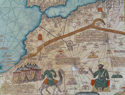
The most explicit and informative features on the Catalan Atlas that may be indicative of the imperial preoccupations of the Aragonese in the late fourteenth century are the depictions of the strategic and economic elements in the Mediterranean. The emphasis on trade routes, especially in the non-European world, in North Africa and the East, highlights the fact that the Aragonese were largely preoccupied with trade, the acquisition of wealth, and the location of resources such as gold. Indeed, the mercantilist nature of the Crown of Aragon is made clear by the Catalan Atlas of 1375, as are the strategic calculations of the Catalans. The map provides intricate details about harbors, navigational routes and nautical aspects of the Mediterranean. Furthermore, there are significant descriptions of North African cities, where the Catalans had managed to secure rights to recruit mercenaries and establish religious institutions, and also where they possessed numerous trading outposts.[14] Moreover, the Atlas carefully delineates between the various political dynasties existing in North Africa, a fact that would have been useful for practical purposes for Catalan merchants and policy makers. Therefore, the attempt by the cartographer of the Catalan Atlas to depict the Aragonese imperium as somehow unified, with Majorca as the primary imperial center, is less informative about the “imperial reality” of the Crown of Aragon than the emphasis by the Atlas on economic and strategic considerations such as trade routes, harbors, and political loyalties. The fact that the Aragonese confederacy was largely held together by commercial and strategic considerations may help to explain why many modern scholars would find the non-political aspects of the Catalan Atlas more useful in understanding the imperial preoccupations of the Crown of Aragon than in attempting to explain the selective use of iconography.
Abraham Cresques, the Catalan Atlas and Majorca
A brief look at the author of the Catalan Atlas, Abraham Cresques, indirectly reveals a great deal about another aspect of the Aragonese imperium in the Mediterranean: the role of minorities. The author’s origins are very important because it shows that he was not a member of the ruling elite of Aragon, but was in fact a member of the conquered indigenous population of Majorca. He also came from a Jewish family, a fact that may have led to his stigmatization, marginalization, and persecution in a place like Castile, but the outlook of the Aragonese meant that minority communities, such as the Jews and Muslims were generally tolerated.[15] Those with scholarly inclinations were particularly prized by the Catalan aristocracy and were actively patronized by the Crown of Aragon. This was the case with Abraham Cresques, who was directly commissioned by Pedro IV, king of Aragon, to produce the Catalan Atlas, which he completed in 1375.
Another important aspect about Cresques that contributes to a broader understanding of the Catalan Atlas is that he came from a long line of Majorcan cartographers.[16] Cartography in Majorca was a refined art, as much as it was a science. Majorcan cartographers derived most of their information from sailors traveling in between the western Mediterranean and the eastern Atlantic. In this way, they managed to acquire detailed information about the Mediterranean and Atlantic coasts from a variety of cartographic traditions. Jewish cartographers in particular were highly skilled because of their access to both Hebrew and Arabic geographical knowledge, and this fact explains in part why Pedro IV chose to extend his patronage to Abraham Cresques. The knowledge of the Majorcan school of cartography was greatly expanded by the activities of the Catalans in the Mediterranean during the 13th and 14th centuries when they managed to bring large swathes of the sea under the domination of the Crown of Aragon. Thus, there is a direct relationship between the expansion of cartographic knowledge in Majorca and the maritime colonization and exploration of the Aragonese. As seen above, the emphasis on political geography by attaching distinctive banners to such places as Majorca, France, and some Muslim states, whose rulers it was practically useful for the Catalans to identify, were hallmarks of the Catalan Atlas. Majorcan maps also recorded maritime history by depicting the existing “reality” of the Mediterranean in cartographic form, not just by showing political geography, but also by showing how nautical technology advanced as time went on. This can especially be seen when one compares the portolan of Angelino Ducert, from 1339, with Abraham Cresques’ Catalan Atlas, from 1375. As David Abu-Lafia has also argued, it is safe to come to the conclusion that “the cartographic evidence thus fits the wider argument that the Catalans, and more particularly the Majorcans [who played a major role in the Aragonese conquests], developed impressive navigational skills in the 13th and early 14th century.”[17]
Indeed, the Majorcan school of cartography remained important well into the fifteenth century and was instrumental in documenting (and contributing to) the role of the Catalans in the exploration and colonization of the eastern Atlantic Ocean, thus paving the way for the discovery of the New World.[18]
The Catalan-Aragonese thalassocracy in the Mediterranean was never a unified entity. At its apogee, the Crown of Aragon could only claim that it ruled the lands between the western and eastern Mediterranean but they often exercised little real power over any of it. The Aragonese imperium was a loss confederacy held together more by economic and strategic considerations than by sheer political or military might. The Catalan Atlas of 1375 is very useful for understanding the imperial preoccupations of the Crown of Aragon, and can be interpreted as representing the “imperial reality” of the Catalan domains in the Mediterranean to a certain degree. Its emphasis on commerce, strategically important locations, and political geography provides modern scholars with an insight into the perspective of the Catalans with regard to their Mediterranean kingdom. Furthermore, the fact that the cartographer, Abraham Cresques, a Jewish Majorcan, was especially commissioned to draw the map by the king of Aragon, Pedro IV, highlights the important role of minorities within the Crown of Aragon and also the prominence of the Majorcan school of cartography in the western Mediterranean. Thus, it is inadequate to simply view the Atlas as a tool of imperialism whose intention it is to reify the existing “reality” of the “Aragonese empire,” but needs to be instead interpreted more broadly as a tool of utility that can, if rightly interpreted, help historians understand the major imperial preoccupations of the Aragonese-Catalan imperium.
[1] P.D.A. Harvey, Medieval Maps (Toronto, 1991), 7.
[2] Harvey, Medieval Maps, 7–17.
[3] Norman J.W. Thrower, Maps and Civilization: Cartography in Culture and Society (Chicago, 1996), 56.
[4] Harvey, Medieval Maps, 43–49.
[5] For more, see Heinrich Winter, “Catalan Portolan Maps and Their Place in the Total View of Cartographic Development,” Imago Mundi 11 (1954): 1–12.
[6] Jean Michel Massing, “Observations and Beliefs: The World of the Catalan Atlas,” in Jay A. Levenson ed. Circa 1492 (Yale, 1991), 27.
[7] Massing, “Observations and Beliefs: The World of the Catalan Atlas,” 27–33.
[8] Fernandez-Armesto, Before Columbus, 151.
[9] Brian Harley, The New Nature of Maps: Essays in the History of Cartography (Baltimore, 2001), 54.
[10] David AbuLafia , “The Role of Trade in Muslim-Christian Contact,” in Dionisius Agius ed. The Arab Influence in Medieval Europe (Reading, 1994), 15.
[11] See, in particular, J.N. Hillgarth, The Problem of a Catalan Mediterranean Empire, 1229-1327 (London, 1975).
[12] Fernandez-Armesto, Before Columbus, 151.
[13] Despite this fact, there is a implication by the mapmaker that the Catalans possessed trading outposts “in the East,” as indicated by placing the senyera on the island of Lesbos, near Asia Minor.
[14] For the relationship of the Catalans with North Africa, see Charles-Emmanuel Dufourcq, L’Iberie Chretienne et le Maghreb, Douzieme-Quinzieme Siecles (Variorum, 1990), III: 161–179 and IV: 469–479.
[15] For more on this, see Harvey J. Hames ed. Jews, Muslims and Christians In and Around the Crown of Aragon (Brill, 2004); John Boswell, The Royal Treasure: Muslim Communities under the Crown of Aragon in the Fourteenth Century (Yale, 1977); Elena Lourie, Crusade and Colonisation: Muslims, Christians and Jews in Medieval Aragon (Variorum, 1990). For an alternate view, see David Nirenberg, Communities of Violence: Persecution of Minorities in the Middle Ages (Princeton, 1996), 69–92.
[16] J.N. Hillgarth, “Sources for the History of the Jews of Majorca,” in J.N. Hillgarth ed. Spain and the Mediterranean in the Later Middle Ages (Ashgate, 2003), XII: 341.
[17] David AbuLafia, A Mediterranean Emporium: The Catalan Kingdom of Majorca (Cambridge, 1994), 204–208.
[18] T. N. Bisson, The Medieval Crown of Aragon: A Short History (Oxford, 1986), 177.
[1] These conquests are described in detail in Damian Smith and Helena Buffery trans. The Book of Deeds of James I of Aragon (Ashgate, 2003).
[2] David AbuLafia, The Western Mediterranean Kingdoms, 1200–1500 (London, 1997), 41.
[3] Fernandez-Armesto, Before Columbus, 34.
[4] Fernandez-Armesto, Before Columbus, 34.
[5] For the Aragonese conquest of Sicily, see Lawrence Mott, Sea-Power in the Medieval Mediterranean: The Catalan-Aragonese Fleet in the War of the Sicilian Vespers (Gainesville, 2003).
[6] For more on the Almogavares and the Catalans in the East, see David Agusti, Los Almogavares: La Expansion Mediterranea de la Corona de Aragon (Madrid, 2004); R. Ignatius Burns “The Catalan Company and the European Powers, 1305–1311,” Speculum 29 (1954): 751–771; Robert D. Hughes trans. The Catalan Expedition to the East: From the Chronicle of Ramon Muntaner (Madrid, 2006); Jose Moreno Echevarria, Los Almogavares (Barcelona, 1972).
[7] AbuLafia, Mediterranean Kingdoms, 118-123. The Duchy of Athens is described in detail in Kenneth Setton, “The Catalans in Greece, 1311–1380,” in Kenneth Setton ed. A History of the Crusades (Madison, 1969), III: 167–277; Kenneth Setton, Catalan Domination of Athens, 1311–1388 (Variorum, 1975).
[8] AbuLafia, Mediterranean Kingdoms, 124-126.
[9] J.N. Hillgarth, The Spanish Kingdoms, 1250-1516 (Oxford, 1976), I: 347-371.For more on political decline in the Crown of Aragon in the 14th century, see Joseph M. Salrach, La Corona de Aragon: Plenitud y Crisis (Madrid, 1996), 76–85.
[10] For the strategic considerations of the Catalans in relation with the North African Muslims, see J.A. Robson, “The Catalan Fleet and Moorish Sea-Power (1337-1344),” The English Historical Review 74 (1959): 386-408.The main primary sources include Lynn Nelson trans. The Chronicle of San Juan de la Pena: A Fourteenth-Century Official History of the Crown of Aragon (Philadelphia, 1991); Mary Hillgarth trans. Pere III of Catalonia (Pedro IV of Aragon), Chronicle (Toronto, 1980); Frances Hernandez trans. The Catalan Chronicle of Francisco de Moncada (El Paso, 1975).
[1] Felipe Fernandez-Armesto, Before Columbus: Exploration and Colonization from the Mediterranean to the Atlantic (Pennsylvania, 1987), 128.
Bibliography
Primary Sources
Cartographic material
Cresques, A. Catalan Atlas of 1375. Bibliotheque Nationale, 1992. (Also in UBC Rare Books and Special Collections)
Non-Cartographic material
De Moncada, F. Expedición de Los Catalanes y Aragoneses contra Turcos y Griegos. Espasa-Calpe: Madrid, 1941.
Trans. Hernandez, F. The Catalan Chronicle of Francisco de Moncada. University of Texas Press: El Paso, 1975.
Trans. Hillgarth, M. and Hillgarth, J.N. Pere III of Catalonia (Pedro IV of Aragon), 1319-1387: a Chronicle. Pontifical Institute of Medieval Studies: Toronto, 1980.
Hughes, R.D. The Catalan Expedition to the East: from the Chronicle of Ramon Muntaner. Barcino: Barcelona, 2006.
Trans. Neslson, L.H. The Chronicle of San Juan de la Pena: A Fourteenth-Century Official History of the Crown of Aragon. University of Pennsylvania Press: Philadelphia, 1991.
Smith, D. and Buffrey, H. The Book of Deeds of James I of Aragon: a Translation of the Medieval Catalan Llibre dels Fets. Ashgate: Cornwall, 2003.
Theoretical material
Biggs, M. “Putting the State on the Map: Cartography, Territory, and European State Formation,” Comparative Studies in Society and History 41 (1999): 374-405.
Brown, L.A. The Story of Maps. Dover Publications: New York, 1949.
Caraci, G. Italiani e Catalani Nella Primitiva Cartografia Nautica Medievale. Istituto di Scienze
Geografiche e Cartografiche dell’universiti degli Studi: Rome, 1959.
Edson, E. Mapping Time and Space: How Medieval Mapmakers Viewed Their World. The British Library: London, 1997.
Grosjean, G. Dokumentation zum katalanischen Weltatlas vom Jahre 1375 (The Catalan World Atlas of the year 1375). Dietikon-Zurich: Urs Graf, 1977.
Harley, J.B. The New Nature of Maps: Essays in the History of Cartography. The Johns Hopkins University Press: Baltimore, 2001.
Harvey, P.D.A. Medieval Maps. University of Toronto Press: Toronto, 1991.
Massing, J.M. “Observations and Beliefs: the World of the Catalan Atlas,” in ed. J.A. Levenson Circa 1492: Art in the Age of Exploration. Yale University Press: New Haven, 1991.
Mollat, M. Sea Charts of the Early Explorers: Thirteenth to Seventeenth Century. Thames and Hudson: New York, 1984.
Padron, R. “Mapping Plus Ultra: Cartography, Space, and Hispanic Modernity,” Representations 79 (2002): 28-62.
Pastor, J.R. and Camarero, E.G. La Cartografia Mallorquina. Consejo Superior de Investigaciones
Cientificas: Madrid, 1960.
Skelton, R.A. “A Contract for World Maps at Barcelona,” Imago Mundi 22 (1968): 107-113.
Stevenson, E.L. Portolan Charts; their Origin and Characteristics. Hispanic Society of America: New York, 1911.
Thrower, N.J.W. Maps and Civilization: Cartography in Culture and Society. The University of Chicago Press: Chicago, 1996.
Turnbull, D. “Cartography and Science in Early Modern Europe: Mapping the Construction of Knowledge Spaces,” Imago Mundi (1996): 5-24.
Winter, H. “Catalan Portolan Maps and their Place in the Total View of Cartographic Development,” Imago Mundi 11 (1954): 1-12.
Secondary Literature
Abulafia, D. A Mediterranean Emporium: the Catalan Kingdom of Mallorca. Cambridge University Press: Cambridge, 1994.
Abulafia, D. The Western Mediterranean Kingdoms, 1200-1500. Longman: London, 1997.
Agius, D. And Hitchcock, R. The Arab Influence in Medieval Europe. Ithaca Press: Reading, 1994.
Agusti, D. Los Almogavares: La Expansion Mediterranea de la Corona de Aragon. Silflex: Madrid, 2004.
Bisson, T.N. The Medieval Crown of Aragon: a Short History. Clarendon Press: Oxford, 1986.
Boswell, J. The Royal Treasure: Muslim Communities under the Crown of Aragon in the Fourteenth Century. Yale University Press: Yale, 1977.
Burns, R.I. “The Catalan Company and the European Powers, 1305-1311,” Speculum 29 (1954): 751-771.
Dufourcq, C.E. L’Iberie Chretienne et le Maghreb XIIe-XVe Siecles. Variorum: Ashgate,1990.
Echevarria, J.M.M. Los Almogavares. Barcelona, 1972.
Fernandez-Armesto, F. Before Columbus: Exploration and Colonization from the Mediterranean to the Atlantic, 1229-1492. University of Pennsylvania Press: Philadelphia 1987.
Ed. Hames, J.H. Jews, Muslims and Christians In and Around the Crown of Aragon. The Medieval Mediterranean: Leiden, 2004.
Hillgarth, J.N. Spain and the Mediterranean in the Later Middle Ages. Variorum: Ashgate, 2003.
Hillgarth, J.N. The Problem of a Catalan Mediterranean Empire, 1229-1327. Longman Group: London, 1975.
Hillgarth, J.N. The Spanish Kingdoms, 1250-1516. Clarendon Press: Oxford, 1976.
Ed. Levenson, J.A. Circa 1492: Art in the Age of Exploration. Yale University Press: New Haven, 1991.
Lourie. E. Crusade and Colonisation: Muslims, Christians and Jews in Medieval Aragon. Variorum: Ashgate, 1990.
Mott, L.V. Sea Power in the Medieval Mediterranean: the Catalan-Aragonese Fleet in the War of the Sicilian Vespers. University Press of Florida: Gainesville, 2003.
Nirenberg, D. Communities of Violence: Persecution of Minorities in the Middle Ages. Princeton University Press: New Jersey, 1996.
Salrach, J.M. La Corona de Aragon: Plenitud y Crisis de Pedro el Grande a Juan II (1276-1479). Madrid, 1996.
Robson, J.A. “The Catalan Fleet and Moorish Sea Power (1337-1344),” The English Historical Review 74 (1959): 386-408.
Setton, K.M. Catalan Domination of Athens, 1311-1388. Variorum: London, 1975.
Setton, K.M. A History of the Crusades,Volume III: The Fourteenth and Fifteenth Centuries. The University of Wisconsin Press: Madison, 1975.
Shneidman, J.L. The Rise of the Aragonese-Catalan Empire, 1200-1350. New York University Press: New York, 1970.


